Datei:Lageplan von Pola, Meyers Lexikon. tom. 13, 1896.jpg

Größe dieser Vorschau: 788 × 600 Pixel. Weitere Auflösungen: 315 × 240 Pixel | 631 × 480 Pixel | 1.009 × 768 Pixel | 1.280 × 975 Pixel | 2.560 × 1.949 Pixel | 5.029 × 3.829 Pixel.
Originaldatei (5.029 × 3.829 Pixel, Dateigröße: 3,45 MB, MIME-Typ: image/jpeg)
Beschreibung
| Beschreibung | |
| Datum | |
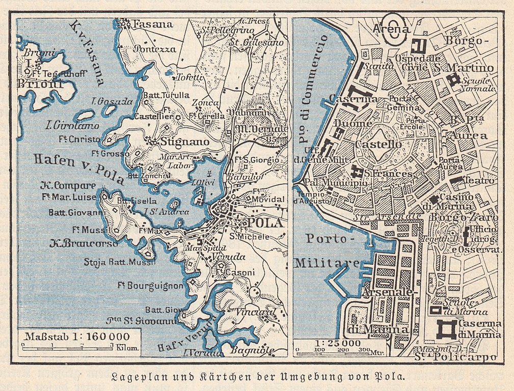
| Quelle | Meyers Konversations-Lexikon, Band 13, 5. Auflage, Leipzig und Wien 1896, Kartengraphik auf Seite 1033 |
| Urheber | Bibliographisches Institut, Leipzig |
| Genehmigung (Weiternutzung dieser Datei) |
public domain |
| Diese Abbildung stammt aus der 5. Auflage von Meyers Konversationslexikon (1893-97). Das Urheberrecht ist erloschen, die Inhalte sind gemeinfrei. | 
|
Dieses Werk wurde vor dem 1. Januar 1899 veröffentlicht und ist anonym oder pseudonym wegen unbekannter Urheberschaft. Es ist in den Vereinigten Staaten sowie in Ländern und Gebieten mit einer Schutzfrist für anonyme oder pseudonyme Werke von 125 Jahren oder weniger nach der Veröffentlichung gemeinfrei.
|
Dateiversionen
Klicke auf einen Zeitpunkt, um diese Version zu laden.
| Version vom | Vorschaubild | Maße | Benutzer | Kommentar | |
|---|---|---|---|---|---|
| aktuell | 18:11, 11. Mär. 2022 | | 5.029 × 3.829 (3,45 MB) | wikimediacommons>Lysippos | {{Information |Description={{de|Lexikoneintrag '''Pola''', ''Lageplan und Kärtchen der Umgebung von Pola''. heute Pula (Istrien)}} |Source=Meyers Konversations-Lexikon, Band 13, 5. Auflage, Leipzig und Wien 1896, Kartengraphik auf Seite 1033 |Date=1896 |Author= Bibliographisches Institut |Permission=public domain |other_versions= }} {{PD-Meyers}} Category:1896 Category:Maps of the history of Croatia (1526–1918) 1896 Category:Maps with a scale of 1:600,000 |
Dateiverwendung
Die folgende Seite verwendet diese Datei: